The Navigator
The offline map you ride with — and everything on it.
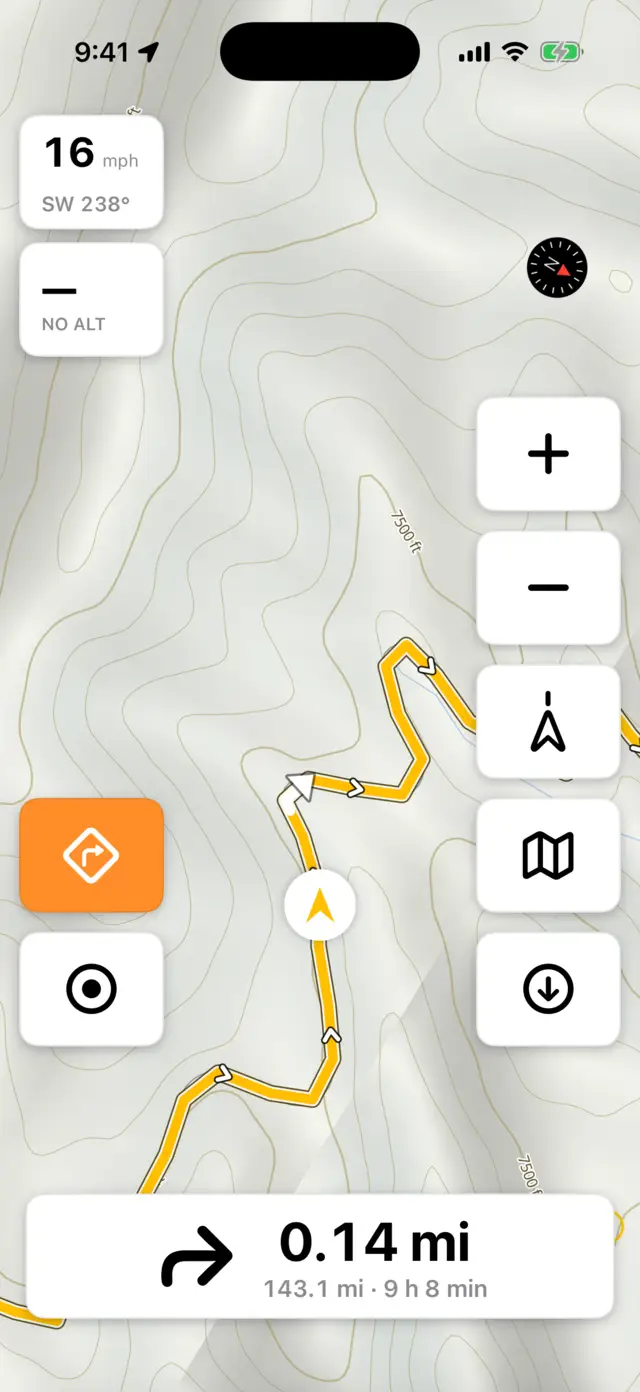
The map
The Navigator draws entirely from maps on your phone — no signal needed, ever (see Offline Maps). It switches between light and dark with your phone, and while you're riding it follows the actual sun: light after sunrise, dark after sunset, wherever you are.
Tracks vs. paths. Dirt roads and tracks — the stuff you came for — draw as a solid brown dash. Foot paths, trails, and bridleways draw as a thin dotted line instead: visibly a trail, visibly not something to ride. It's a real distinction, not decoration — a track chain that dead-ends into a dotted path is a dead end for a motorcycle, and ADV Routing won't route down one.
The ride HUD
Around the map you get your speed, compass heading, and altitude with a grade arrow (ALT tile). While navigating, the next turn shows as a cue — icon, distance, and name — with the remaining distance and time underneath ("207.9 km · 3 h 33 min", or "129.2 mi" in imperial). Tap a HUD box to shrink or grow it.
The cue sits along the bottom of the screen, centered, and the tab bar tucks away for as long as you're navigating so it has the room. Your speed and altitude stay in the top-left corner and don't move — not when a cue appears, not when one goes away — so the number you're glancing at is always in the same place. Stop navigating and the tab bar comes back. If you'd rather it stayed out of the way, tap the bare map to hide it; that choice sticks, and starting a ride won't undo it.
Lock the screen
Rain on the glass, a glove, or a jacket cuff shouldn't pan the map or jab a button. Long-press (or double-tap) the map button and pick Lock Screen: the tab bar tucks away, a Hold to unlock pill takes its place, and every touch on the map and controls is ignored — while your speed, altitude, and turn cues stay right where they are. To unlock, hold the pill for about a second; a stray tap won't do it. Rotating the phone clears the lock.
Kilometers or miles
Set it in the app under Offline Maps → the Units row: Auto, km, or mi. Auto follows your phone's region. On the website it's a separate control — Account Details → Units → System default / Metric (km, m) / Imperial (mi, ft).
Pick imperial and the whole ride switches over: speed in mph, altitude and climbs in feet, distances in miles — on the phone, on CarPlay, and on Android Auto. Voice guidance changes with it, rounding to hundreds of feet instead of fifties of meters: "In 500 feet, turn left."
The two settings are linked in one direction only: change Units on the website and the apps pick it up the next time you open them. Changing it in the app is that device's business alone — it never travels back to your account, and a phone and a tablet each keep their own. Set it on the web if you want it to stick everywhere.
Navigating a GPX track
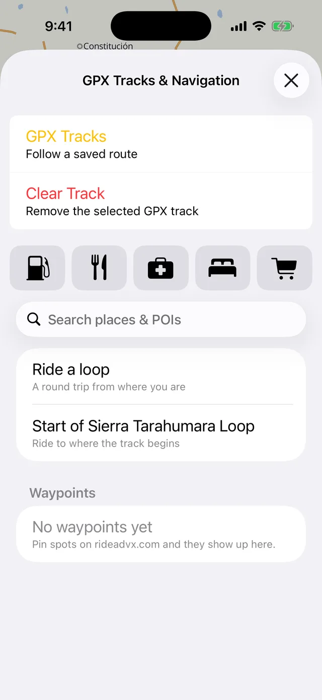
- Tap the map button to open GPX Tracks & Navigation. Once you've downloaded an ADV Routing pack it opens on Ride to — place search, POI filters, your waypoints, and Ride a loop — with GPX Tracks at the top for saved routes. Without a routing pack it opens straight on your track list, which needs no pack and no subscription.
- Pick a track. Anything in your library is here; tracks you've opened before are cached for offline. The navigation button appears in the bottom-left corner as soon as something's loaded — it isn't there before, because there'd be nothing for it to do.
- Start moving — navigation arms itself and voice guidance reads the turns ahead: "In 400 meters, turn left" (or "In 1,300 feet" if you ride in miles). The stretch of track through the next turn lights up white on the route, with an arrowhead where you come out of it — so the turn is drawn as part of the line you're following, and never mistakable for the amber arrow that is you. Don't want to wait for it to arm, or want it off? The navigation button starts and stops it by hand — that's all it does, so a tap is never a surprise.
- Drift off the line and you'll hear about it: an Off track banner with your distance from the route, and a nudge to head back.
Long-press (or double-tap) the navigation button for the ride menu — everything that needs a loaded route: Skip This Turn, Reverse Track to ride it end-to-start, Mute Voice Guidance, and Routing Profile when you're on a computed route.
The map button holds the two that don't need a route, so they're there whether you're riding a track or not: Lock Screen and Remote GPS… (guide). Same gesture — long-press or double-tap.
When you don't take the turn
Detours happen — a closed road, a fuel stop, a track that looks better than the one you planned. Two taps cover it, and they're the same control read two ways.
- On the route: the ride menu's Skip This Turn retires the turn you're being shown and moves on to the next one. For when you can see the instruction and you're not taking it.
- Off the route: tap the red Off track banner and choose Skip Ahead. ADVx takes the deviation as intended and goes quiet — no banner, no nagging — until you rejoin the line. An amber Skipping ahead card stays up so you know it's still there, and navigation picks up wherever you come back, however far along that is. The alternative, Back to Route, just leaves the arrow pointing home.
Both are on the phone and on both car screens — CarPlay's Route list and Android Auto's More screen — because the car screen is exactly where digging the phone out isn't an option.
Finding places
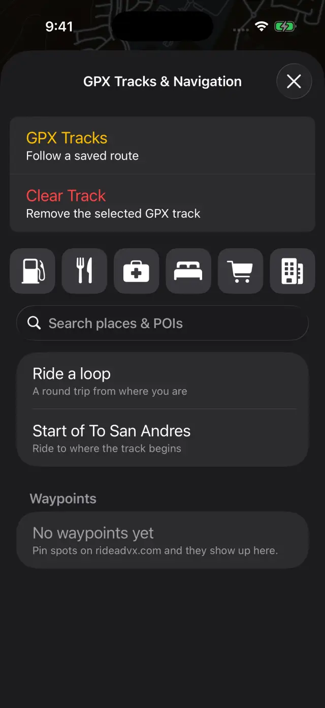
Search places & POIs works offline against your downloaded maps. Six one-tap categories sit above the search field — Fuel, Food, Health, Lodging, Store, and Towns, which covers cities down to hamlets — each browsing nearest-first from where you are. Tap a category and type to filter within it (tap Towns, type a name, and only matching settlements remain). Tap a result to see it on the map, or route straight to it with ADV Routing.
Weather while you ride
ADVx Pro — what's included
With the app open, ADVx keeps an eye on the sky for you — severe weather where you are, and along the route you're navigating. When something's coming, a banner drops in over the map with the headline and the detail. There's nothing to switch on: your position is checked as you ride, and picking a route in the Navigator starts watching the whole line ahead, timed to roughly when you'd reach each part of it.
One honest limit: this works while the app is open. It's not a push notification — a backgrounded or closed app stops being watched, and you won't get buzzed with the phone in your pocket. Planning ahead is the GPX Planner's hour-by-hour Route weather; this is the heads-up while you're actually out there with the screen on.
On the car screen
ADVx Pro — what's included
Plug in and the Navigator moves to CarPlay or Android Auto: the same offline map, turn cues, Start / Stop Navigation, Reverse Track, recording controls (Save Ride), place search, and a one-tap Crew Comms join — all without touching the phone. Built with rally towers in mind as much as trucks.
Good to know
- The Ride to screen routes you anywhere with ADV Routing while keeping your GPX track on screen. Clear Destination drops the computed route but keeps the track; Clear Track drops the track. Whichever applies sits right under GPX Tracks, so it's one tap either way.
- Voice cues cover turns, bearing left/right, U-turns, and roundabouts ("at the roundabout, take the 2nd exit").
- Riding to a track's start? Pick Start of <track> in the Ride to screen and the track stays visible, dimmed, while you get there.